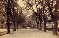
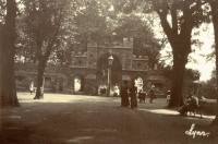
Historic images of The Guannock Gate – Grade II* Listed
Click on the thumbnails for a larger image
The Guannock Gate was originally part of the town’s defences, which included the nearby South Gate on London Road. Guannock is the name for the bank which formed part of these defences. They enclosed a large area and ran from north of The Fisher Fleet, via The Walks, to the South Gate and beyond to Whitefriars. It is likely that only the gates and a short section of the wall either side were made from brick or stone. The rest comprised earth banks and ditches. The defences were called into action during the civil war of the 1640s, when Parliamentarian soldiers blockaded the Royalist town. In the end lack of supplies caused the town to surrender – the defences were never breached. In fact the Parliamentarians improved them, making Lynn the strongest fortress in the region. When the Civil War ended, the defences began to decay.
Part of the town defences were finally removed in the 1800s to make way for increased traffic and new developments. The construction of the railway line also saw large sections being dismantled. Only the South Gate, Guannock Gate and remnant of wall survive. The Guannock Gate eventually became an ornamental feature of interest for people promenading through The Walks.
English Heritage Grade II* listing details
Remains of North Guannock Gate with flanking walls. Late C13, the remains consolidated and romanticised in 1800’s. Brick, carstone and ashlar. Central pointed dying arch springing from square turrets with a crenellated parapet, repeated on turrets. One arched opening right and left below a punched oculus and more crenellations. Crenellated walls run north and south from this point: 3 segmental brick niches to each serving arrow slits. The whole is a symmetrical Picturesque garden composition.


